R
Rain. Until around mid-June, when you say “Oregon” you say “rain.” We started on June 3. The math is easy. It rained most of the day into Eugene OR from the time we started in Florence, giving us a soggy initiation. The second day, we cycled through light rain and a little snow. On the third day, we had occasional showers. On the fourth day, we had a sprinkle or two of rain and snow. From that day on—over a distance of nearly 3,000 miles—rain fell on us for exactly an hour-and-a-half. Near the Wyoming-Nebraska border, just as we lost sight of Laramie Peak in the western distance, a thunderstorm broke. We covered up as best we could and raced for the little town of Lingle, and sheltered for the duration in a city park gazebo. The storm lasted about a half-hour, exciting, but brief. About two weeks later, as Greg and I were riding towards our rendezvous after the Fourth of July break, it rained lightly for about an hour. For the rest of the time, we missed the rain. In Boise, for example, we woke to rain but, by the time we’d breakfasted (on nary a pancake that day) and were on the road, the rain had quit. It rained half a dozen times during the night, but was done by morning. We met Greg’s brother, Jim, and his family for lunch in Lebanon OH, and while we were dining convivially inside, the lightning and thunder crashed and rain fell in sheets. By the time we made our farewells, the storm was over. It was amazing to us how we missed all the rain, but we were glad for it. Riding in the wet tends to pall after a bit, even though we whistle among the drops and tell ourselves it’s “liquid sunshine,” after the Northwest manner of speaking. But we are desert rats after all is said and done. Make our sunshine dry.
Rest days. Through the planning stages and all the way across Oregon, I figured we’d be resting one day out of every week. All the big tours I’d looked into build about five rest days into their cross-country schedule. As we got into Idaho, and Mary kept asking when we were going to take a day off, it became evident that Greg and I had contrary views on the subject. I have to admit, though, that his was based on long-haul experience and mine was mere supposition. By the time we’d ridden two weeks it got to be a joke; Greg would give me a rest day only when I’d shed a bucket of blood. However, after two long, grueling days of riding against the wind for a hundred miles a day, we took an extra day in Casper, just about three weeks after we set out from the Pacific coast. We didn’t take another rest until the Fourth of July break, about two weeks later. We put the time around the 4th of July into the schedule. We estimated that we’d be in Illinois at that time, so Greg arranged several days in Peoria IL while I set up a visit with friends in Springfield. We parted in Keosaqua IA, Greg angling north to the star-crossed crossing at Burlington, I pedaling southeast to Keokuk and Hamilton. I stayed overnight on the Fourth with Mary Sue in Hamilton, going with her and friends to the Keokuk American Legion for catfish, a favorite family watering hole. The next morning I set off for the 105-mile ride to Pleasant Plains IL, outside Springfield, where I’d stay with Barb and Charlie until the 8th of July. Charlie and I had a great time visiting the impressive new Lincoln Library, tooling around Springfield to see our house on S. MacArthur and to ooh and ahh at all the development at the university since I left in 1996. It is a vastly different place now. But for all that I did see a surprising number of people I knew—a few more than a dozen, I think. The main event of the Fourth of July break for me was the pot luck dinner Charlie and Barb put on at their house for about a dozen old friends and colleagues: Carl and Roberta, Leroy and Johnetta, Dottie and Dave, Andrea and Lynn, Bob and Liz, and Lamar. It was fun to see them all again and to stuff myself with the delights they brought to our table. We look forward to seeing them soon in the desert. Greg fared similarly, but with his wife, Rhonda, at his side. She works for a Peoria insurance company, and had returned to that city from Green Valley for a week in the main office. She goes back to Peoria frequently enough that she could arrange her work there to coincide with Greg’s presence. After eating steaks from the grills of friends and family for a couple of days, he rode about sixty miles south to Williamsville to his brother-in-law’s place for the final night of our break. On the morning of the 8th we rode through the rain to meet at Dawson. My friend, Lynn, met me in Sherman IL and rode with us to a Buffalo café for a “breakfast supplement.” From that morning on we rode for two weeks without a break all the way to Cape Henry.
Return trip. More often than not, when people asked us if we were going to bicycle back to Arizona, they were making a joke. As we got closer to the end of the line, the humor wore out of that joke. We never, ever, thought of biking home. From the beginning both of us had planned to fly Southwest back from Raleigh-Durham to Tucson. In Fredericksburg VA we were close enough to the end that we could figure dates, so I made my flight reservation for July 28. My brother, Rich, picked me up at the Ocean Front Public Library (see Virginia) and we drove back to his home in Clarksville, near the North Carolina border, for six days of sightseeing amongst the wonders of the area—chiefly “Pauper’s Knob,” Rich’s farm, about seven miles from town. I also called bike shops in the Raleigh to check on having my bike boxed up for the flight back and was shocked to discover that they wanted three days and $100 to do the job. Demurring, I took the big cardboard boxes Rich offered and cut them up to tape together a bike box. It worked pretty well, though the tape it took to make the box weighed almost as much as the bike. I also needed a big duffle bag to check through the rest of my gear, but there was no place in Clarksville that sold such things. Rich to the rescue again: I took one of the burlap gunny sacks he had lying around. It was just the right size and, when I hemmed up the top and threaded a rope through, it closed in just the right way, as well. Southwest had informed me accurately about the cost of shipping my bike ($50), so I was not stunned at the check-in desk. The clerk took my home-made bike box without comment, but balked at the gunny sack. “The charge for non-traditional baggage is $15,” she said glancing sidewise at the sack with a slight curl on her lip. “What for?” I responded. “This baggage is as traditional as it gets.” She could not be persuaded to my point of view, so I forked over a ten and a five feeling that I was financing a Corrupt System. I think I probably got $30 worth of righteous indignation out of the transaction, which proved only that poetic justice was on my side. The trip home was uneventful. I had a four-hour layover in Baltimore, which was something of a revelation. I used to enjoy layovers. They gave me time to lounge around and watch people moving through airports. Since 9-11, though, it’s all changed. The places they put chairs now are away from the main concourses, off in little nooks where the traffic is slight and, usually, off in a direction that makes your neck ache when you look too long. Also, the din of cell-phone chatter makes the people-watching ambience much less pleasant than it was in the days when sensory overload came from the too-strong smell of fresh buttered popcorn. Not so much fun anymore.
When I got the bike box back in Tucson, I saw it had been opened by Homeland Security. I guess the x-ray image of all those pipes and wires must have been too much to resist. But the bike was OK, except for a slightly bent rear wheel, and an excessive amount of bright yellow Homeland Security tape. I don’t think they deigned to look at my “non-traditional” burlap luggage. Living down near the Mexican border, I am aware of the work of Homeland Security –mostly political image-making, it seems to me—and don’t find much to recommend that department of government. They do have great tape, though; it sticks well and apparently there is a lot of it. Greg had pretty much the same experience a day later.
Rivers. It seems strange that rivers hold a powerful attraction for one who is blasé about oceans. Maybe it’s because I grew up by The Father of Waters; maybe it’s because water is so scarce where I’ve lived for the past dozen years. But it is true. When we coursed along a river, or crossed one, my eye, mind, and heart were livelier somehow. And what a litany of life and legend their names sing: Siuslaw, Mackenzie, Crooked, Ochoco, John Day, Willow, Snake, Boise, Wind, North Platte, Platte, Big Blue, Missouri, West and East Nishnabotnas, Nodaways, Fox, Des Moines, Mississippi, LaMoine, Illinois, Sangamon, Wabash, White, Miami, Scioto, Hocking, Ohio, Cheat, Potomac, James. Some of these streams have personal associations: Each time I’ve traveled along the Crooked River near Prineville OR I’ve seen a Tricolored Blackbird. I’ll always associate the Wind River in Wyoming with the last time I backpacked. The White River I remember for what a dump it was as it wound through Indianapolis (it looked a lot better this time, I’m happy to report). The Potomac, well downstream from where we crossed in July, holds many memories of my time in Washington D.C. back in the Sixties. Those little waterways in western Iowa, the Nishnabotnas, the Nodaways, the Waubonsie, are names I grew up with, reading them in the newspapers every spring when they flooded. And, of course, all those middle rivers, from the Fox, in Iowa, to the Sangamon, in Illinois, are home waters. Others have public associations; the Snake with Lewis and Clark; the Ohio with the history of industry in America; the Wabash with the songs. Salman Rushdie wrote a book about a sea of stories in which the various currents are genres. Imagine the book of river stories, each tributary lending its characters and plots to the grand story of stories that is the Mississippi. Mark Twain had a good sense of that flow. Growing up by the Mississippi, I did, too, although the perspective of youth is more from the banks, a single standpoint, than from the flow itself, that gathering, mingling, carrying through space and time. From the bank it is true to say “You can never step in the same river twice,” which is a nonsense proposition from the standpoint of the flow. It says, “Roll on! Roll on!”

2 July. The DesMoines River at just below flood stage in Keosaqua IA. A week earlier it had been over its banks. The historic Hotel Manning, where we stayed, had water lapping its doorstep. (Our digs were actually in the little low building behind the magnificent pile.)
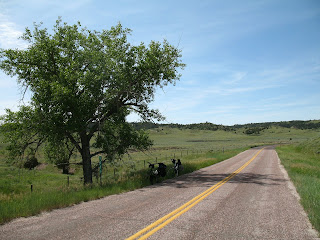
Roads. The best road for biking is one with broad, paved shoulders and little traffic. Over the whole length of our trip we were fortunate to have so many days on roads that would make a “better”category. US 26 was a pretty good road for nearly 2 ½ states, from Oregon to Nebraska. Out west, the traffic is lighter, so two-foot shoulders, like the ones on most of US 26, suffice. We rode I-84 and I-86 in southern Idaho, except for some short portions where back roads paralleled the big highways. Interstates, contrary to common opinion, are really pretty safe. The shoulders are eight to ten feet wide, so when one rides on the right side of them there’s far more room between bikes and motor vehicles than on ordinary roads. The noise and fumes of the interstate may be irritating, but they are not life-threatening on the ride itself. The best road on the entire trip, US 50 between Parkersburg and Clarksburg WV, was just like an interstate, except for the I-something number. What it did have, though, was a lot of big blue signage: “Robert C. Byrd Appalachian Highway System.” These appeared every few miles. Most politicians are lucky to get a street named after them, let alone a system of highways. Until his recent fits of truthtelling on the Iraq war, I have spent my entire political life despising Robert C. Byrd and what he stood for. But he is not “The King of Pork” for nothing, and his Appalachian Highway System is a thing of beauty. There is no grade steeper than 5%, which is achievable in West Virginia only by chopping the tops off mountains and filling up the valleys with them, a method the highway department probably learned from the big coal companies. Let me take my hat off to the august Senator for the chutzpah of his “system.” Having said that, I do wonder how extensive the system is. Does it appear anyplace else in Appalachia other than that fifty-mile stretch between Parkersburg and Clarksburg? And, for the record also, let me say that Senator Byrd’s name appears no place on US 50 east of Clarksburg, the worst road we encountered on the whole trip, worse even than highways under construction, because it is so dangerous. The section of US 50 from Clarksburg to Romney WV winds over the highest ridges of the

16 July. The Robert C. Byrd Appalachian Highway System. Just look at those shoulders!
Appalachians. It is narrow. It is in bad repair, full of holes, big cracks, and slumping at the edges from the weight of countless gravel, coal, and timber trucks. It has no shoulder and, at some places, there is a drop-off at the edge of the “pavement” eight to twelve inches deep—ditches worn by cars and trucks that have gone off the right edge because the road is so narrow. It was dangerous (see Close calls ) and scary, but beautiful, too, if one had a moment and the courage to look. We saw mountain azaleas in bloom on that stretch of road, and appreciated the shade of ancient trees as we climbed in the fierce heat and humidity. But I was glad when we put that road behind us. The second worst road was IA 2, which goes in a nearly straight line all the way across the southern edge of the state. I remembered it as a pretty good road from driving it, and Greg had crossed the state on it several years ago when he biked from Green Valley to Peoria IL. But within two miles after we crossed the Missouri River from Nebraska, I, as a native Iowan, felt the need to apologize to Greg for the condition of road. It is an old highway, mostly concrete, with gravel shoulders. Now gravel shoulders are never good, but Iowa apparently keeps its gravel loose. If a couple of trucks meet on the road alongside you, you have to get off the road into the gravel. Narrow tires can do weird things under such conditions, the worst is when they turn leftwards and throw you back into the lane of traffic. So we had to be super cautious. Unfortunately, the recent flooding had closed some of the bridges on US 34, a route which parallels IA 2 about forty miles north, so a lot of traffic shunted down to our road. Many of the old concrete stretches of the highway were in bad condition, as well. Great V-shaped hunks of concrete had broken off the edge, and there were lots of cracks, holes, and bad patch jobs. The directors of RAGBRAI (the annual Great Bicycle Race Across Iowa) selected IA 2 as the route for their big ride—for 15,000 cyclists—about five years ago. They should be brought up on charges of criminal negligence, if there is any justice at all. Certainly my feelings of attachment to my native place are looser for having to grudgingly tolerate that roadway all the way across the state.
In general, the western roads were better than the eastern. They are clean; most of them have paved shoulders; there is less traffic on them, as you’d expect from looking at our route. Nebraska’s roads were the best of all. US 26 and US 30 were both good, with the sole exception of some shoulders being worked on in “them hills around Lewellen.” East of the Missouri, however, the decay of infrastructure is evident. Perhaps the new administration will turn that around. And perhaps pigs will fly.
Roofs. Greg was our traveling expert on mechanical matters. But I was the roof guru. Not any roof, though. My reigning passion is for composition shingles, usually buffy-gray in color, and interlocking, that were sold at the beginning of the Twentieth Century. It’s not often you see a roof of that vintage unless it’s tile or slate. But those old shingles last. They lasted so well, in fact, that they ceased to be manufactured after the First World War. I first noticed them thirty years ago in Basco IL, a little crossroads village about ten miles from Keokuk. Since then, I’ve seen them in the east and as far west as Nebraska. I noticed a few across southern Iowa, but was thrilled to discover more in my pilgrimage to Keokuk than I had ever seen there previously. At a splendidly roofed old brick house I noticed while biking around town, two young men were washing a car. I approached them and congratulated them on their vintage roof. On of the young men looked up and said it wasn’t his house; it was his uncle’s. And his uncle was just about to tear off the old roof and put on a new one. Now I am not one to stick my nose into other people’s business, but my passion moved me to advise him to tell his uncle to leave the roof alone because it would outlast the bricks. I was thrilled in some of the old eastern towns to note how many of those roofs were still around and looking good. Greenfield IN, Athens OH, Parkersburg WV, and Clarksburg WV all had quite a few examples, but the capital city for everlasting composition roofing shingles is Chillicothe OH. Like many of the older towns along our way, it’s heyday was from the late 1890s through the First World War. Recently there has been a lot of restoration work downtown and the place is starting to look spiffy. Adding to the luster of the town are its dozens, perhaps hundreds, of houses and other buildings that are roofed with my favorite shingles. If you should get there, have a look. Maybe they will give you a thrill, too.
Root beer shakes. I can’t remember ever having my rightful fifteen minutes of real fame, but I have built a small legend in the family on my passion for Dairy Queen. Mary likes to tell people how I’d stop at DQs in every small town until I became a family man, at which time I got on the nearest interstate and drove like a maniac to our destination, just as everybody else does. There is some truth in the legend, though, particularly for summertime travel. Summer is the time for root beer shakes. There is just no confection as satisfying on a hot day as a DQ root beer shake. Try one. Don’t be put off if the counter person looks blank when you order. Many of them have never heard of root beer shakes. You might be asked if you want a root beer freeze. Say yes. Sometimes, if you order a root beer milk shake, they will put in both root beer and milk, which will dilute the root beer flavor and make the shake runny. A freeze is just the soft ice cream with root beer mixed up in it. That’s what you want. I love them. Mary and Ben came close to accusing me of riding across the country just so I could stop at all the Dairy Queens along the way. It was a temptation, I’ll admit. But, as a matter of fact, I had just four root beer shakes on the whole trip. That’s just one every 800+ miles, a sorry record. Moreover, one of them wasn’t even root beer. In Parkersburg WV the local franchise committed to a Mr. Pibb distributor. So, at their urging, I tried a Mr. Pibb shake. Don’t waste your time. It tasted like funky soda pop and was not at all refreshing.
 1 July. The Dairy Queen in Leon IA; I recommend it.
Route. People sometimes wondered how we chose the route we took across the country, as though we made a single choice among several options. Here’s a multiple-choice question for you.
Craig and Greg took their route because
a. They chose Florence OR as their point of departure.
b. They wanted to finish at Cape Henry (Virginia Beach) VA.
c. They made assumptions about how to get across the Appalachians.
d. They relied on information gathered during the ride.
e. They had little choice once they started down the road.
f. They played it as it lay and decided on their routes crossroad by crossroad.
g. They picked roads on which motels could be found about a day apart.
h. All of the above.
If you chose “h,” you may pin a gold star to your tunic. Picking Florence rather than Astoria as our jumping off place committed us to crossing the High Cascades at McKenzie or Santiam Pass. Once we arrived at Sisters OR it was easy to choose US 26 across Oregon and most of Idaho because motels on the only other option, US 20, were too far apart. That’s also the reason we took I-84/I-86 from Boise to Pocatello: other possible routes lacked lodgings at appropriate intervals. Probably the most significant choice we made about Idaho (apart from leaving the interstate to ride to Paradise!) was to leave US 26 at Swan Valley, east of Idaho Falls, and pedal to Jackson WY via Victor ID and the Teton Pass. (see Climbs). We thought that way would be shorter and more scenic. It was certainly that, but it was also much steeper and, from Victor to Jackson, clotted with traffic. Later I learned that most of the cross-country bike tours plying US 26 continue on that road to Jackson. It follows the relatively flat valley of the Snake rather than aiming straight at the heights. Nonetheless, we have no regrets. The Teton Pass road was dramatic, challenging, and beautiful. A good example of a decision governed by motel availability was when we chose to bypass Riverton WY and take WY 133-134 to Shoshoni so that we’d have a more manageable distance to our next possible motel stop, Casper. Shoshoni was a world of anxiety for us because we nearly had to sleep outside in the cold (see Motels), but it was closer to Casper by a couple of hours. The ride to Casper turned out to be so grueling that we took our first rest day there. We chose to enter Nebraska via Torrington and US 26 rather than by way of Lusk and US 20 again because of the way motels were spaced. Once in Nebraska, it was a no-brainer to stay on US 26 and, after Ogalalla, US 30, because the towns were spaced comfortably apart and were replete with tourist services since they were all so close to I-80. From Seward NE we turned south to Lincoln and NE 2 in order to connect with IA 2 which runs straight across Iowa’s southern tier of counties. After Iowa and our Fourth of July break, it was an easy call to pick US 36/US 40 for crossing Illinois and Indiana—they are straight as a string and, again, familiar to both of us. We figured our way from Eaton OH diagonally through Germantown, Lebanon, Wilmington and Greenfield so that we could arrive in Chillicothe. That destination was predicated on our choice of US 50 to take us across the Appalachians. We labored for a while on that one. Greg called bike shops on that highway in West Virginia and Virginia to ask about it. Some thought US 50 was unsafe; others thought it was safe because bicyclists rode it frequently. A draw. We finally chose US 50 because the options were small roads of uncertain character that wound God knows where through the mountains. Adventure Cycling, a touring organization, sells a set of maps of its preferred route across the country, but they weren’t very helpful in the East because their roads didn’t go to Cape Henry. So US 50 seemed the logical choice for us. It was, after all, a federal highway and a major route across the mountains, so how bad could it be? (see Roads) US 50 took us across West Virginia to about 20 miles east of Winchester VA. The rest of the route, necessarily a diagonal from Winchester to Virginia Beach, was so distant and unknowable to us trying to decide in Green Valley that we left it to be decided day by day on the basis of local knowledge. See Misinformation and Virginia for an account of how local knowledge impacted rational decision-making! But the roads we chose did finally take us to Virginia Beach and Cape Henry as well as offering us lots of adventures and opportunities for second-guessing. How would we go from coast to coast if we were to do it again, you ask? Well, it would depend on where we chose to start and finish, etc.
Even in a country you know by heart
It’s hard to go the same way twice.
The life of the going changes.
The chances change and make a new way.
Any tree or stone or bird
can be the God of a new direction. The
natural connection is to make intent
of accident. To get back before dark
is the art of going.
Wendell Berry, “Travelling at Home”
S
Snow. It was a wet Spring all over the country and record snowpacks were recorded at some places in the West. We started in the first week of June, which meant that it was still cold and wet. We’d intended to cross the High Cascades at the McKenzie Pass on the way to Sisters OR, but the road was still closed. People told us there was still eighteen feet of snow on the roadway and lots of fallen trees. The road wasn’t expected to open until August. So we climbed over the Santiam Pass instead. And we did it in falling snow. We also biked through a brief snow squall at the Ochoco Pass east of Prineville OR. Snow did not actually fall on us as we passed over the Tetons and the Rockies, but the highways cut through vast and picturesque snowfields. The only restroom we saw climbing up to the Teton Pass was still half-buried in the snow, and though we rode on a warm, sunny day over Togwotee Pass in the Wyoming Rockies, we were amazed that the meadows along the road were covered in several feet of snow. All that snow in the West presaged the flooding we’d see in the Midwest. By the time we crossed the Mississippi, however, it was all about summer heat and humidity in which even the thought of snow quickly melted away.
 17 June. Lots of snow at Togwotee Pass WY. I supposeI could have perished there!
Spectacular day, Most. Several people asked us what was our best moment of the trip. It is hard to know exactly what they meant to ask, but I always took the easy way out and spoke of spectacular scenery. On the 17th of June we biked north out of Jackson (Hole) WY on a road which paralleled the Teton range. For thirty miles we looked only to our left, transfixed by the spectacular, snowy, picture-postcard mountains. When we turned east at Moran Junction, the same mountains were in view behind us for twenty more miles. For five hours we pedaled with arguably the most splendid mountain scenery in the lower 48. It is hard to imagine a more spectacular day. However, I must admit there were moments I liked even better. I loved it when we were able to leave the heavily traveled roads and ride the country byways. The road to Paradise was memorable, and not just for the name. Perhaps best of all was the little back road between Douglas and Torrington WY on a beautiful, sunny Sunday morning. We even picnicked undisturbed under a shady cottonwood in
 22 June. Our spectacular picnic spot.
its westbound lane. Another memorable byway was between Bloomfield and Keosaqua IA. Its pastoral tranquility was marred only by an extended clan of hyper-aggressive Jack Russellesque dogs (see Dogs). A lot of what makes a good moment or day is contextual. Back roads are more attractive when you’ve just been on an interstate for a while. The contours of eastern Indiana were more refreshing for just having traversed the pool-table flatness of west-central Illinois. Likewise, a cool breeze in West Virginia and Virginia would have perked us up remarkably…had there been one.
Speed. If you don’t ride a bike much, it is hard to imagine how far an ordinary person can go in a day, and how fast. Most folks are nearly felled by the thought of riding seventy miles on a bike. Yet a lot of them would say things such as, “Yep. The next motel’s up at Smallville. That’s about forty mile; take you about an hour.” Yep, indeed. We seldom traveled that fast and, when we did, it was never for more than a minute or so. Forty miles per hour is really fast for normal riders, though racers in the Tour de France are said to go screaming down Alps or Pyrenees at a 65 mph clip. The fastest I have ever cycled—down from the top of Madera Canyon with a wicked tailwind—was 47.5 mph (and a fear factor of just about 100!). On the trip my highest speed was 44.5 mph down a short, but steep, hill into Paradise Valley ID. My slowest pace was 2.5 mph going up Teton Pass and a few other similar grades. That is really slow; at just under 2.0 mph I lose my balance and fall over! We averaged just about 10.8 mph per day for the whole trip. On the one day when that average was my actual average daily speed—July 17th, on the road from Wilmington OH to Chillicothe—my speed ranged from 3.5 to 40.0 mph. You can guess which figure is for an uphill and which is for a down!

No comments:
Post a Comment