C
Cities. When I think of long-distance cycling, I picture country roads, forests, fields, hills, and long vistas. Most people probably see it the same. What we forget is that roads through the countryside usually exist to connect cities. Ay, there’s the rub! Cities are generally confusing and dangerous places. The shoulders of highways tend to end at the city limits. Bike lanes, if there are any at all, terminate suddenly, throwing one into traffic lanes. Left turns at intersections of busy four- or six-lane roads can be extremely treacherous. And most discombobulating of all, signs disappear as if the city streets are as familiar as one’s own driveway, so you must find your way by your own shriveled wit—not a happy circumstance. If you’re lucky enough to find a pedestrian (the rarest of human types just when they are most necessary) to give direction, the chances are poor that he’ll be helpful. (see Misinformation) The most difficult city to get around in was Twin Falls ID, a small town, really, but clotted and fast-paced (see also Close calls ). The most mysterious city was Richmond VA. The highway we rode in on became a busy thoroughfare with no bike lane, as usual, and no highway signs, also as usual. We knew we were near the middle of the city where there should be a sign for VA 5, but it didn’t appear, and the locals we asked either had never heard of the highway, or didn’t know for sure ( had nary a clue) where it might be. We knew we had to avoid I-95 while somehow managing to get to the other side of it. Our maps were not very detailed; they showed no precise junction with VA 5, but did seem to indicate that a big toll highway became VA 5 at the end of its short (say, 3-mile) length. So we went down the on-ramp, threw our quarters in the basket, and entered the nearly deserted tollway. It was a nice ride for a while; then it suddenly got very busy and we figured it had dumped us right onto I-95. We were now criminals. We had to find an exit. Greg was well ahead of me, pumping like crazy, when I saw he was crossing the James River Bridge, a landmark that screamed “YOU”VE GONE TOO FAR!” I yelled and waved, to no avail, and finally had to race across the river to stop Greg. He’d had his head down, watching the road’s edge he was riding for glass and trash, of which there was a record amount, (see Bungee cords ) and didn’t even notice the river or the exit he’d passed. Well, we had to go back. That meant riding that trashy road’s edge again, against the traffic—criminality compounded! Curiously, only a couple of cars honked at us. But the State Police car that passed us immediately turned on his blinker to exit the road. We knew what for, and pedaled furiously to the exit which, blessedly, led to a maze-like railway yard, with industrial buildings and parking lots. It wasn’t where we wanted to be, but we figured it kept us out of jail. Eventually, we found ourselves in an old downtown area, where we asked a couple of people how to get to VA 5 and got some plausible answers. After a half-hour we were on our road. Unfortunately, it was not what we expected—no motels—so we had to leave it and strike out for the airport area about five miles away. I felt very strongly that we would be far better off when Richmond was behind us. Writing this, I still shudder to think of the place.
The easiest city to get through was Indianapolis. Having had a hard time finding our way through there after delivering Beth to Earlham College, a hundred miles to the east, I was dreading trying it by bike. So we sought advice. In a gas station on the far west side of town we spied a tow-truck at a gas pump. What better route advisor than a tow truck driver? We asked him the best way to get through the city. He said, “Go out on this street, jog left in two blocks and you’ll be on Washington.” He pronounced it Warshington. “Just stay on Warshington.” “But how about downtown?” I asked. “Stay on Warshington,” he said. “All the way to the city limits?” I inquired. “Stay on Warshington.” “We’re going on to Greenfield,” said I, testing a little. “Just stay on Warshington.” And it was just that simple.
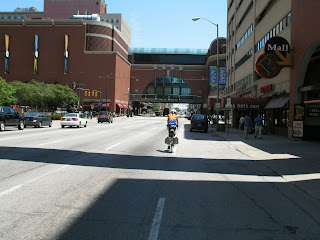 July 10. Aged biker in jaw-dropping jersey riding through downtown Indianiapolis on Warshington Street.
Climbing. From the vantage point of a bicycle saddle, it seems pretty much uphill from the Pacific Ocean to the Atlantic. This biker’s illusion is based in the hard fact that you spend more time and energy climbing hills than you do coasting down them. I did not calculate the difference, but I’d guess that a third of cross-country pedaling time is spent laboring up hills. Before the ride, when I thought of climbing it was the mountains that occurred to me, and not just mountains, but ranges: Cascades, Rockies, Appalachians. Of course, you climb particular hills, up to particular passes. There were some great climbs. The Santiam Pass, over the Cascades was not high (4718’), but it was long (6 miles), and made miserable by rain, snow mixed with rain, and my very sore right ankle. The steepest, and ostensibly most difficult, was the Teton Pass (8431’) which boasted grades of 10% and more over eight miles. ( Most modern mountain highways are engineered for 6% grades.) The road was narrow and the traffic heavy, so to enjoy the beauty of the snow and forests we had to pull off the road, so we really had several climbs going up that one. Descending the other side into Jackson WY was harder; the grades were even steeper, up to 12%, so we were squeezing brakes as hard as we could down the curvy, nine-mile mountainside. Braking so long and so hard really gets you in the shoulders, wrists, hands, and arms; you feel the descent more than the difficult climb. Most bikers taking US 26 across Idaho and Wyoming skirt the Teton Pass by staying on that highway. We didn’t choose the hard climb; we went via the Teton Pass because it looked to be the shorter way to Jackson. Compared to the Teton crossing, the climb over Togwotee (pronounced TUH-guh-tee) Pass (9579’) to crest the Rockies was a piece of cake. The grade was normal, and we got help for about a half-mile of the ascent. There was road construction going on and the road crews did not permit bikes to cross the construction zones because trying to ride a bike uphill, over clods and rocks, would slow the flow of traffic too much. So, they carried us up—put us, our bikes, and our gear into the back of a pick-up and drove us to where the pavement resumed. It was a welcome, and hilarious, respite. The Appalachians, in a way, posed the greater challenge. We knew, from biking over the 10,000’ passes in the Colorado Rockies in 2007, that we could climb mountains. We just didn’t know about the eastern ranges. We had read of daunting experiences with the “straight up and straight down” mountain roads of the East, and a West Virginia bike shop owner whom Greg talked to on the phone confirmed the legends by saying that some people ride all the way across the country only to quit in the Appalachians because the roads were just too steep. Though we felt that claim had the odor of hillbilly chauvinism, it did cause us to wonder. So we faced the last two days in West Virginia with some trepidation. We weren’t really relieved to hear a young fellow in Grafton WV tell us that “It’s a pretty drive over to Romney, but there’s some hills.” We knew there were “some hills:” we were just in the dark about how high and steep they were. The next-to-last day was almost a perfect 10 in the Tough category. It was in the 90s, drippily humid, the hills were long (say, about 3-4 miles) and steep, and we had to get over a hundred miles of them to get to our motel in Mt. Storm. It was really hard, mostly because the road was so bad—narrow, no shoulders, in terrible condition, with holes, ruts, and drop-offs at the edge of what passed for pavement (see Roads). Our last day in West Virginia, which I had figured would be the most difficult, wasn’t, luckily for us.
The hardest climb of the trip for me was over some nameless hills on the road from Bridgeport NE to Ogalalla NE. I had reckoned that, since we were passing from the high plains to the agricultural expanses and the Missouri River, we’d be going downhill all the way. When I mentioned my supposition in a conversation with a convenience store clerk in Oshkosh NE, she said, “Maybe so, but there’s them hills around Lewellen.” I almost lost it in “them hills.” It wasn’t that they were so high; elevation gains were less than some of the mountain passes. But they were long, long, long; the day was hot, hot, hot; the wind was right in our faces. My mind went. Instead of relaxing, breathing correctly, and letting my energy concentrate in my leg muscles, I started thinking how long and hard the climbing was, how hot it was, how I detested the wind, and, generally, how miserable I was and would be for hours and hours to come, confirming it all by too frequently checking my watch and odometer. At the end of that 92-mile day, in the space I reserved for characterizing the difficulty of the day’s ride, I entered “H+”, super-hard. I might as well have entered “S+”, for super-stupid. Like any other physical activity, biking is mental, and I was having a profoundly retarded day.
The hardest climb of the trip for me was over some nameless hills on the road from Bridgeport NE to Ogalalla NE. I had reckoned that, since we were passing from the high plains to the agricultural expanses and the Missouri River, we’d be going downhill all the way. When I mentioned my supposition in a conversation with a convenience store clerk in Oshkosh NE, she said, “Maybe so, but there’s them hills around Lewellen.” I almost lost it in “them hills.” It wasn’t that they were so high; elevation gains were less than some of the mountain passes. But they were long, long, long; the day was hot, hot, hot; the wind was right in our faces. My mind went. Instead of relaxing, breathing correctly, and letting my energy concentrate in my leg muscles, I started thinking how long and hard the climbing was, how hot it was, how I detested the wind, and, generally, how miserable I was and would be for hours and hours to come, confirming it all by too frequently checking my watch and odometer. At the end of that 92-mile day, in the space I reserved for characterizing the difficulty of the day’s ride, I entered “H+”, super-hard. I might as well have entered “S+”, for super-stupid. Like any other physical activity, biking is mental, and I was having a profoundly retarded day.
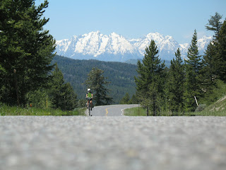 June 17. Climbing up to Togwotee Pass (9579'), on the spine of the Wyoming Rockies.
Close calls. Sometimes I think that bike riding is a lot like NASCAR racing: the race is the thing but the crash is the draw. People seem to be inordinately interested in how dangerous it is to ride a bicycle. We fielded a good many questions about accidents narrowly avoided, dangerous drivers, malicious or otherwise. Well, they’re right. Biking is a dangerous pastime, but not that dangerous. A biker should have two watchwords, Visibility and Vigilance. Bright clothing is an important part of the program, even if those screaming colors are not what you’d choose for ordinary street dress. One school of opinion holds that the loud jerseys (see Jersey ) signify an unseemly surrender to the corporate interests which manufacture and market the plastic clothes sported by Lance Armstrong and other heroes of the Tour. The Northwest is home to this school. Some of my friends and family are among its adherents. As a lover of sparrow-colored clothes, I incline to it myself. But I don’t see any advantage to bicycling in earth-tone plaid shirts. The object while biking is not to blend in but to stand out. You can control part of the risks of the road by being visible. The other part that’s up to you is watching for danger: keeping your eye on the road ahead so you can plan for the unexpected end to the bike lane, or the hole in the pavement, or loose gravel, or the hundred different causes for a crash or spill; looking into your rear-view mirror at the traffic coming up from behind—are they going too fast, or seeming to come to close, or making a turn that would cut you off; and riding predictably so the drivers will not be in a panic when they pass. But even the freakiest-dressed and most cautious rider can be at risk. I think we had surprisingly few close calls over the 3299 miles we rode, a handful each would just about account for them. Sometimes they are the rider’s fault. A good example would be the time I about got creamed in Twin Falls ID. The situation was typically urban, trying to turn left at a busy intersection of multi-laned roads. Greg, who was riding ahead, took advantage of a break in traffic and slipped from the right gutter over into the left turn lane. I was following about a hundred yards behind and found myself trapped in the gutter by at least two lanes of speeding traffic. The intersection was wild, with traffic speeding across the other way in the first millisecond of a yellow light. I couldn’t just get off and walk my bike because there were no “Walk” signals. So, I decided to turn right, ride a ways in the direction opposite of that I wanted to go, then find a place to cut across the road to the desired eastbound lanes. But when I turned right, the craziness of the traffic was compounded by mall parking lots emptying out on both sides of the street. I got a little bewildered and tried to get over to a median when I shouldn’t have. If a driver had not stopped his left turn into a mall, I’d have been roadkill. All I could do was beat my breast in contrition and mouth an “I’m sorry!” That’s the only time I came close to being the instrument of my own demise. I don’t think Greg ever did.
A second sort of situation is more common: you’re riding along visibly and vigilantly when a vehicle accidentally just about hits you. A good example of that was on US 50 in West Virginia as we were climbing the highest mountains on our next-to-last day in that state. It was a terrible road—old, narrow, and crumbly (see Roads). I was laboring uphill when a car came up behind me just as a big logging, coal, or sandstone truck was coming downhill in the westbound lane. The road was probably not wide enough for the three of us and, because of the mottled shade, I could not see what the condition of the rocky shoulder (if any) might be. I moved over to ride the last millimeter of the road’s edge when the edge of the pavement fell away. My back wheel swerved right, leaning me right into the lane of traffic. Luckily, the car and truck passed as I was struggling to stay upright. How, I do not know. Another time, on IA 2, a car coming up behind Greg was so close it drove him off the road.
Some such incidents are clearly malicious. East of Tuscola IL a pair of red gravel trucks came over to the very edge of the roadway, missing us by inches, air horns blaring. I think they were just having sport at our expense but, had we wobbled at all, it would have been a blood sport. I recorded more than half a dozen other instances of less perilous harassment, but they are pretty much par for a bicyclist’s course. In eastern Idaho, a group of young men threw a drink can at Greg while hurling insults at him, as well. The can missed and the insults were incomprehensible, but both stung, anyway. Clarksburg WV was the capital of harassment on the trip. It’s one of those cities you think of in connection with “dump” or “armpit”; its downtown is entered through a parking garage. As we passed through the town on the way to our motel, five separate cars full of teenagers shrieking insults passed me. Again, the language was impossible to understand, though the tone was not. This sort of harassment is better seen as bad manners than as a close call, stupid adolescents trying to behave in ways that their mamas didn’t raise them to.
Coffee. On Wednesday morning, June 11, the ninth day out, I gave up coffee for the duration. It was cold and rainy that morning in Boise, no time for an old guy to be swilling diuretic drinks. I had been stopping to relieve myself four or five times on a day’s ride, on average, and was beginning to worry that I wouldn’t have time to ride across the country. So I hoped that cutting out caffeine would help me along the road to Virginia Beach. I don’t know that it did. The average number of pit stops didn’t diminish until we started measuring our perspiration in liters when entered the heat and humidity of the Midwest and East. Still I persisted, lapsing only once, in Chillicothe OH, when we arrived early in the afternoon and I thought a cup of coffee and a roll (alas, no cinnamon buns were available!) would be a nice treat as I toured the old Victorian section of town. Some ten days later, I was really keen to break my fast on the first morning at my brother’s house in Clarksville VA. He and nephew Ryan had gone off to work early, leaving me to make my own coffee. Perfect! I could make it at my preferred strength without having to hold back for others. I don’t know what happened—whether it was the coffee, the pot, or my fallibility, or some demonic synergy of the three—but the coffee was awful. Undrinkable. I poured the evidence down the drain, got on my bike and rode to MacDonald’s. Every morning thereafter, I walked someplace—Uppy’s, MacDonald’s, Burger King—for my coffee. I figure I really ended my period of abstinence on July 29, when I made my morning pot of coffee in Green Valley.
Cost. A few people have wondered how much a trip like ours costs. I can answer that question: $3,231.66, which amounts to $0.98/mile over 3,299 miles. The biggest expense was lodging, $1501.18, followed by food, $1,068.41. I spent $73.21 on the bike; $360 on air fare back to Tucson; and $228.86 on miscellaneous expenses, mostly on gifts. Surprisingly, the total was very close to my estimate. The tour I’d signed up for in the Spring of 2006, which I had to resign in order to undergo the seven-week course of radiation for my recurrent cancer, would have cost me about $6,500 for a fully-supported trip. Today that same trip costs $8,552. Other fully-supported tours are similarly expensive: Crossroads Cycling offers one for $8,995 and the Womantours equivalent is $8,590. These “fully-supported” rides usually include a motel room shared with one other person, two meals a day, a couple of refreshment stops on each day’s route, a van to haul luggage from motel to motel, and a free T-shirt or jersey. There are other supported tours that are cheaper, but they are camping tours—motel options are quite a bit extra. CycleAmerica offers a camping tour for $6,000; Adventure Cycling has one for $6,499; Wheels Across America, a Christian witness tour that our friend, Shirley (see Dedication), joined in the ‘90s, costs about the same. It would be possible, if you camped and bought food at groceries much of the time, to do a transcontinental trip for $2500. That option, however, is not for old people who have become so accustomed to comfort that they can no longer sleep on the ground or eat out of cans.
Cyclists, Long-distance. We saw about 20-25 other long-distance cyclists on the road, all but one of them before we crossed the Missouri River into Iowa. Most of them we stopped to talk with, but a couple were pedaling westward on the other side of a divided highway which allowed no contact. I think our route from the Pacific through Nebraska was a favored one for cyclists. We saw almost all of them on either US 26 or US 30. The first bunch we met in Mitchell OR. They were headed for Cape Henlopen DE, camping with their sag wagon that hauled all their gear from one campsite to the next. In the same camping grounds was a sixty-something man with a great set of red panniers. We wanted to talk with him, too, but he eluded us, perhaps by simply riding West. In Vale OR we talked with an earnest young Christian who was traveling to somewhere on the West coast with three other fellows from Tennessee. We met a few more people as we rode I-84 in Idaho (see also Roads).A group of seven cyclists from Missoula MT were following the Lewis & Clark Trail to Astoria OR. Along that route we also met a retired man who cycled a lot, and had fabulous equipment with real waterproof panniers, front and back, an expensive touring bike, and various gizmos he’d made for his own convenience. He’d previously biked to Alaska, which seems to me an enormous feat. This time he left his home in Jacksonville FL and was biking kitty-corner across the country, through Colorado and Wyoming, to Bellingham WA. At a convenience store on the road from Jackson to Dubois WY we talked to a couple college-age guys who were traveling East-to-West, camping along the way, towing those bike trailers that look like large scooters without handles. I’ve always imagined that they would be hard to pull, but the young guys said not, except for uphill grades. A big exception, since uphill grades take up most of your time on a long trip! They were also greatly dispirited—just about ready to turn around and go back East—by the headwind they’d been riding into for days. Greg and I had been enjoying an 8-day tailwind and, with a degree of mindless noblesse oblige, wished them a tailwind for the rest of their journey. We should have cherished our good fortune with greater care. Not ten minutes after we left them, the wind turned and stayed strong and in our faces for more than a week. (see also Wind). Down the road, in Lexington NE, we met a young Scotswoman at our motel. Gillian took a four-month leave of absence from her job at the National Library in Edinburgh, and from her husband, also in Edinburgh, to ride across America from San Jose CA to Quebec City, Canada. She was riding alone, amazingly enough, not at all concerned about the dangers everybody else dwells on, and was having a wonderful time. We saw her again in southern Iowa, rode with her for several hours, enjoyed a very nice piece of gooseberry pie, on her tab, at the Junction Café in Bedford IA, and parted company. I was sure we’d see her again, since she was going our direction, but we never did. We have since communicated by e-mail; her card, showing addresses and such, was headed Cycling across North America—mostly fueled by pie. My kind of girl!
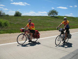 June 30. Riding IA 2 east of Clarinda with Gill, a prodigious lover of pie--and a Scot, to boot!
We also saw another young woman who was cycling from New York to the Pacific coast by herself. I don’t believe we’d have seen women riding alone twenty years ago. Some people we talked to thought we should not see it today, citing all those lunatic rapists that lurk in the dark corners of our country. The weirdest get-up we saw on a long-distance cyclist was on a young man in his early twenties on the return leg of his South Bend IN-Lincoln NE trip. He was cycling towards the Missouri River in the heat and humidity of the Midwest in long pants, wooly sox and sandals, a heavy sweater, a woolen cap pulled down around his ears, and a big pack on his back (no panniers or bags on his bike, at all). The only rider we saw east of the Missouri was a young Marine who pulled over to talk with us in Tuscola IL. We were the first bikers he’d seen, and he’d come all the way from Annapolis MD on his way to the Los Angeles area. He had come over US 50 and reported it was fine, except for traffic in the Washington D.C. area (see also Roads and Misinformation). Most of the cross-country cyclists starting north of San Francisco would head towards New England, across what we call The Northern Tier. Those starting in Southern California would likely meet the Atlantic in Yorktown VA (the terminus of the classic Centennial Ride in ’76) or further south than our route, in the Carolinas.
Day, typical. We’d wake up at around 5:15 or 5:30, unassisted by alarms, desk calls, or other unnatural intrusions. (Only once, after lying awake with a migraine during the night, I slept until 6:30. Greg, ever patient, was creeping around in the dark, wrestling with his conscience over whether to wake me up.) We’d make our ablutions, pack up our bikes (which we kept in the room with us), and go off to the lobby for the continental breakfast offered by the motel or to a restaurant for pancakes. We were usually on the road by 6:30 or 7:00, though it was a little later in Oregon, where folks sleep in longer than they do in other parts of the country. Once we got to Nebraska, all the restaurants were open by 6:00 so we were on the road earlier. We usually stopped for a “breakfast supplement,” a snack and something to drink, if we came to a restaurant or convenience store after 20-30 miles. Lunch would typically be in a fast food restaurant another couple of hours down the road. By 3:00 or 4:00 we normally had completed our ride and had checked into our motel. Greg would ride off in search of his post-event carbs (see Appetite), while I washed out my sox, shorts and jersey, and took a shower. By that time, Greg would be back, laundering and showering. I’d compile data and jot down the daily adventures in my crabbed little script, while Greg pored over the next day’s route and motel possibilities. We had dinner at around 6:00, or a little after. Greg often bought some microwaveable food at a grocery, which he ate in the room; I’d go off to some restaurant. It would take some discriminating arguments to conclude which of us ate better fare (see Food). By about 7:30 we’d be back in the room, reading, fixing an inner tube or some article of clothing, or watching TV (see NBA Finals). Greg introduced me to The Dog Whisperer, on the National Geographic Channel, which I viewed avidly for seven different nights, I believe, until I realized that all the programs were pretty much the same. But it is a great show. Cesar, the whisperer, makes a lot of sense and does remarkable rehabs on a lot of pretty awful dogs. My favorite was a truly nasty little yappy Chihuahua, who, when his attempt to bite Cesar was stopped by a shush, turned and burrowed into the sofa behind his mistress like a maniacal gopher. Even after that sort of excitement, we were asleep by 8:30 or 9:00. I won’t bore you with an account of my nighttime peregrinations (see Infirmity).
Directions. (see Misdirections and Misinformation)
Dirt. I wanted to bike across the country for a lot of reasons. Foremost, I suppose, was the cachet of having done the ride of legend. Almost everybody who’s ever set foot to pedal wants to do it, and people who find their pedals on pianos or cars are, nonetheless, immediately impressed by the epic character of such a ride. I suppose, too, that there’s an element of denial behind it, too: I am NOT too old to make a 3,000-mile bicycle trip. Patriotism was part of my motivation, too; crossing every foot of my country’s span is a way of assimilating it, making it my own—being able to say this is MY country. I have always felt my patriotism most intensely as a geographic response. When I’d return to my home in Iowa after I had left it for good in the 50s, I’d feel my heart soar when I came to the bluffs of the Mississippi, the landforms of my birthplace. So it is with the country, too. America the beautiful; its majestic mountains, fruited plains, shining seas—the whole proud, albeit hackneyed, bit. By the time you’re my age and have traveled a little, all the conventional landscapes are well-known. Biking across them and through them is a way to know them differently. I now know how they smell, how they sound, how they appear to the senses in the tinier elements you can only see when you pass slowly by. On this trip I recognized an aspect of America I’d never seen before. Dirt. You could make a gorgeous national flag from the marvelous palette of soils: yellow, brown, ochre, beige, gray, purple, black and, yes, red, white, and even blue. American dirt, I salute you! Lava soap salutes you!
Disappointments. The High Cascades are beautiful mountains, a series of snow-covered volcanoes rising high from the dark green fir-forested hills. In Oregon there are nine or ten such peaks in a north-south line, extending from Mt. McLaughlin, at nearly 10,000 feet, in the south near California, to the conical majesty of Mt. Hood, over 10,000 feet, near the Columbia River in the north. In between lie Mt. Jefferson, the most symmetrical of them, the jagged peaks of Three-fingered Jack and the Three Sisters, and the lesser eminences of Mt. Washington, Broken Top, Mt. Bachelor, and Diamond Peak. There are some spots, to both the east and west of the mountains, where one can behold much of the range in one breathtaking vista. Mary and I visited old friends Colleen and Arnie in Bend, on the western slope of the Cascades, a week before Greg and I passed nearby on our bikes. From the friends’ porch we could take in the view—blue skies, snowy peaks, picturesque clouds, dark firs. The greatest of the very few disappointments on our trip was that Greg, who loves mountains and has never really seen the Cascades, missed out on the view. They were socked in, covered with gray clouds. It snowed as we breasted the Santiam Pass; it rained intermittently the rest of the day; and the following day, as we rode east from Redmond in bright sunshine, the mountains were shrouded in clouds. We thought we saw part of a snow-capped peak (probably Three-fingered Jack if it wasn’t a cloud) as the gloomy overcast broke up around a patch of blue. That was it. I was heartbroken that Greg missed the inspirational view, but he was philosophic about it, feeling pretty confident that he’d have ample viewing time when he and his wife, Rhonda, come to Oregon on their motorcycle.
Dogs. You have to wonder how a dog might respond to “What’s not to love about a bicycle?” I’ve been riding bikes around country roads for more than fifty years and, over that span, dogs have been a constant theme of conversation among bicyclists. Everybody who’s ever touched foot to pedal has a dog story to tell. Mine used to be how the big dogs north of Springfield cut my biking compass almost in half. It got to be just too harrowing to venture north. The worst day was when three German Shepherds raced out and surrounded me, barking viciously and looking frighteningly bloodthirsty. I got off my bike and tried to put it between me and the dogs, a difficult task because there were three of them. I couldn’t just run away; that would expose my flanks, so to speak. So I danced about with the bike for about 15 minutes, until they wearied, got hungry enough that kibble seemed easier, or got called away, I forget which. Biker friends and I used to argue about which dogs were the worst. My view was that multicolored dogs—the black, white, and brown ones—were more dangerous than bicolored ones, regardless of breed. That was before Rottweilers got popular and mean. But all those stories and images from the past got erased several years ago when we met Black Dog of Tumacacori. He took up residence at the Santa Cruz Spice Factory, just south of the historic Tumacacori Mission, about 25 miles south of Green Valley. When he first came barreling out of the driveway at me, I was riding solo to the next town, Rio Rico. I saw him coming, made him out to be a Chow, and reckoned that he would behave according to his breed: display viciously at the gate to make sure I kept on going, but not venture onto the road. Wrong! Black Dog did, indeed, look like a Chow from the front but, from the back, he looked like a Greyhound. And the back end did the running. Black Dog was not only fast enough to keep pace as we raced away at 20+mph, but had the stamina to keep up for a quarter-mile or more. He snapped at legs and feet, so it was necessary to keep veering away from his head. Escaping the jaws of Black Dog was a fearsome, exhausting, and dangerous piece of work. The route past the Spice Factory was a popular one, so he terrorized a lot of bikers. Some of them, along with Greg and me, got pepper sprays to deter him. After getting spritzed a few times, Black Dog got the point. Then, all I had to do was to point a fist his way for him to think “PEPPER SPRAY!” and come to a skidding halt, like Wiley E. Coyote suddenly realizing that he was about to burst into the Roadrunner’s trap. About a year after his education, Black Dog was taken away by the County Animal Control Truck. He never returned, but we’re confident that he’s found his bliss tearing out from behind clouds to intimidate Ghost Riders in the Sky.
Given the ongoing symbiosis of bike and dog, you might ask about how many times we were chased on the 3,299-mile road to Virginia Beach. Amazingly few, as it happened; less than a dozen for the two of us. Greg had more bad experiences than I did. Being younger and swifter, he often rode ahead and caught the unfenced dogs when they were fresh and full of high spirits. By the time I came along, several of them were tired or bored already, or had found better things to do. Though Greg had some encounters in Idaho, Indiana, and West Virginia, most of our canine adventures came along Rt. 2 in southern Iowa. I don’t know why so many more dogs ran loose there; differences of wealth, status, culture, and power appear slight among Iowans and their kindred in Nebraska and Illinois. But, on one stretch of back road between Bloomfield and Keosaqua IA, we were so pestered by dogs it got comical. We inferred that a Jack Russell terrier was the most successful breeder in those parts. Every farmhouse seemed to have one, and all the dogs looked and acted the pretty much the same. The worst, by a degree or two, was a more rotund version of a Jack Russell, who came tearing down the hill at me so fast and furiously that she ran right into my rear wheel. I don’t know if her nose got tweaked by the spokes, or not, but the bump seemed to satisfy her bloodlust.

No comments:
Post a Comment